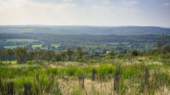
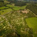
Louargat Forest

EcoTree

  clear sky

  13.78  °C
temperature

  93  %
humidity

  4.76  km/h
wind

  1021  hPa
atmospheric pressure

The Louargat forest is located on the Hoguéné mountain, one of the highest points in area Côtes-d’Armor, offering a splendid view of the surrounding countryside. It is home to the flower called Scilla, which is a protected species.
Since our acquisition, a great deal of work has been carried out to allow the reforestation of a new high forest on this previously clear-cut area. Today, Douglas fir, Scots pine, Sitka spruce and red oak saplings are flourishing there. The forest has also been recognised as being a type I Natural Zone of Interest for Ecology, Fauna and Flora (ZNIEFF).

The municipality of Louargat stretches from the town of Saint-Eloi to the forest of Coat an Noz and Coat an Hay. It borders the Menez Brè, The summit of Trégor, where the Guindy river passes. The name Louargat comes from the saint Ergat from Brittany. It is also believed that Louargat comes from the old Breton Loer or Loar (the moon) and cat (combat) or loc ar goat (place of the wood), due to its location in the middle of the Coat-an-Hay forest.

PEFC Certification : : Yes

Management turnaround : Dec 10, 2019

Forests : Temporarily closed to the public, the reopening is scheduled on 01/03

Cartography

A photo of Louargat Forest

Photographs